Roman Millom (43-c.410 AD)

Richard Saul Ferguson (1837-1900) was an antiquarian and barrister from Carlisle. One of the founders of the Cumberland and Westmorland Archaeology and Antiquarian Society in 1866 (which has been going for over 150 years), he became editor of the Society's Transactions in 1868 and president of the Society in 1886. Under his direction the castles, churches, houses, manuscripts, and old customs in most of Cumberland and Westmorland were recorded. His own specialist period was the Roman occupation of Cumberland and he significantly expanded the collection of Roman antiquities at Tullie House Museum.
That there was a Roman military presence in Furness - and subsequently Millom - was accepted as fact by most late 18th Century and 19th Century antiquarians. Ferguson is, however, the most specific. In his article Roman Cumberland and Westmorland, Transactions, Vol 3, 1878, Ferguson states: Agricola, in A.D. 79, advanced from the Isle of Anglesey into Scotland by the western coast, crossing the estuaries, and, Roman-like, securing his retreat by the formation of a good road, guarded at frequent intervals by fortified posts. During this advance he kept close to the sea, partly we suppose that he might be supported by his fleet, partly to avoid the trackless woods, and wild mountains of the interior. This Roman road starts from Lancaster, crosses the Lancaster branch of the Morecambe estuary to Pigeon Cote Lane, near Wyke in Cartmel; passes Flookburgh, where part of this Roman road still remains; thence crosses the Ulverston estuary and goes by Mountbarrow and Lindal to Dalton, near to the second of which places its pavement was long ago discovered.... Thence the road would cross the Duddon Sands and enter Cumberland somewhere near Millom. From Millom it would run by Bootle and Ravenglass to the great camp at Moresby .... Here is an extract from his map outlining the route:
 1860 Map: Archer's Field above Gallow's Field (Courtesy of the National Library of Scotland)
Acceptance Turned on its Head
1860 Map: Archer's Field above Gallow's Field (Courtesy of the National Library of Scotland)
Acceptance Turned on its Head
 Self Portrait as Sea Captain, W.G. Collingwood
W.G. Collingwood (1854-1932) was an author, artist, antiquarian and Professor of Fine Arts at University College, Reading.
Born in Liverpool, Collingwood lived in Coniston for many years and in the 1890's joined the Cumberland and Westmorland
Archaeology and Antiquarian Society becoming editor of Transactions in 1900. In his article The Angles in Furness and Cartmel,
Transactions, Vol 24, 1924, Collingwood asserts, "there are no forts or roads of Roman construction in Furness and Cartmel.
But there are many Roman coins and other relics from different sites, especially from the neighbourhood of the "British
settlements."" By default, therefore, he did not believe the Romans were in Millom either.
Other antiquarians in the 20th Century followed Collingwood's challenge: there is little mention of the Romans in this part of
Cumbria henceforth. Even local historian Frank Warriner in his The Millom District A History, 1974, has little to say on
the subject: "There are but slight traces of the Roman occupation in the Millom district. Agricola passed through it on his
march north in A.D. 78."
A piece of red sandstone, with the word ANTEF carved on it, was found in the north wall of Holy Trinity Church during the 1930
reconstruction; it has been placed inside the church, above the aumbry niche in the south wall of the sanctuary (on
the right behind the altar).
Self Portrait as Sea Captain, W.G. Collingwood
W.G. Collingwood (1854-1932) was an author, artist, antiquarian and Professor of Fine Arts at University College, Reading.
Born in Liverpool, Collingwood lived in Coniston for many years and in the 1890's joined the Cumberland and Westmorland
Archaeology and Antiquarian Society becoming editor of Transactions in 1900. In his article The Angles in Furness and Cartmel,
Transactions, Vol 24, 1924, Collingwood asserts, "there are no forts or roads of Roman construction in Furness and Cartmel.
But there are many Roman coins and other relics from different sites, especially from the neighbourhood of the "British
settlements."" By default, therefore, he did not believe the Romans were in Millom either.
Other antiquarians in the 20th Century followed Collingwood's challenge: there is little mention of the Romans in this part of
Cumbria henceforth. Even local historian Frank Warriner in his The Millom District A History, 1974, has little to say on
the subject: "There are but slight traces of the Roman occupation in the Millom district. Agricola passed through it on his
march north in A.D. 78."
A piece of red sandstone, with the word ANTEF carved on it, was found in the north wall of Holy Trinity Church during the 1930
reconstruction; it has been placed inside the church, above the aumbry niche in the south wall of the sanctuary (on
the right behind the altar).
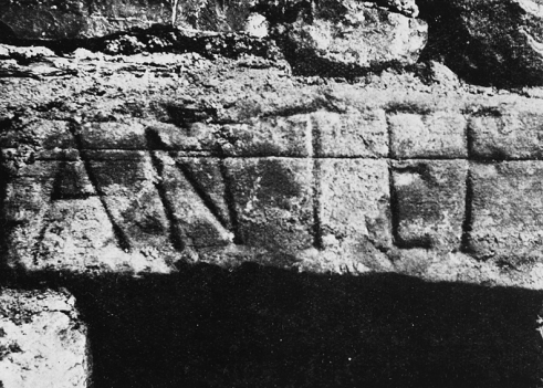 Originally it was believed this was Roman and had possibly been brought to Millom from the Roman site at Ravenglass.
However, leading expert on Latin text and epigraphy, Roger Tomlin, has recently suggested it is not Roman. Dan Elsworth,
the archaeologist who led the Community Dig in 2024, suggests it could be part of an early Christian post-Roman inscription,
of a type more typically found in Wales and Scotland, but likely to also exist in Cumbria given the evidence for Christianity
in this area from an early date.
Originally it was believed this was Roman and had possibly been brought to Millom from the Roman site at Ravenglass.
However, leading expert on Latin text and epigraphy, Roger Tomlin, has recently suggested it is not Roman. Dan Elsworth,
the archaeologist who led the Community Dig in 2024, suggests it could be part of an early Christian post-Roman inscription,
of a type more typically found in Wales and Scotland, but likely to also exist in Cumbria given the evidence for Christianity
in this area from an early date. There are two possible links to Egypt: could it be a reference to one of the three emperors Intef I, II and III also known as Antef? Or could it be connected in some way with Antef the Good Shepherd?
Back to Acceptance? Daniel Elsworth
 graduated from the University of Edinburgh in 1998 with an honours degree in Archaeology, and began working
for the Lancaster University Archaeological Unit in 1999, which became Oxford Archaeology North in 2001. He became a project
officer and for over seven years worked on excavations, surveys, building investigations, desk-based assessments, conservation
and management plans. These have principally taken place in the North West. He has a particular interest in the archaeology
of the area and has published a number of articles on aspects of archaeology and history in the region, details of which can
be viewed on the website Academia. Since 2005 Daniel Elsworth has been a Director of Greenlane Archaeology, Ulverston, who
have carried out over 400 projects mainly in North West England.
Elsworth examined previous arguments for and against the Romans being in Furness which, of course, has implications for them
being in Millom. In his article, 'The "Streetgate" at Conishead, the "Castellum" at Dalton, and Roman Furness', Transactions,
Vol 7, 2007, he shares further evidence which suggests the Romans were in Furness and, in light of more recent archaeological
finds, asserts there was, indeed, a 'strong background' presence in Furness during the Roman period and concludes,
"The identification of a road across the Furness Peninsular obviously has implications for claims made of roads to the north,
leading up the west coast, and south, across the Cartmel Peninsula."
Since Elsworth wrote his paper there have been further archaeological finds, as the following map shows:
Daniel Elsworth
Daniel Elsworth graduated from the University of Edinburgh in 1998 with an honours degree in Archaeology, and began working
for the Lancaster University Archaeological Unit in 1999, which became Oxford Archaeology North in 2001. He became a project
officer and for over seven years worked on excavations, surveys, building investigations, desk-based assessments, conservation
and management plans. These have principally taken place in the North West. He has a particular interest in the archaeology
of the area and has published a number of articles on aspects of archaeology and history in the region, details of which can
be viewed on the website Academia. Since 2005 Daniel Elsworth has been a Director of Greenlane Archaeology, Ulverston, who
have carried out over 400 projects mainly in North West England.
Elsworth examined previous arguments for and against the Romans being in Furness which, of course, has implications for them
being in Millom. In his article, 'The "Streetgate" at Conishead, the "Castellum" at Dalton, and Roman Furness', Transactions,
Vol 7, 2007, he shares further evidence which suggests the Romans were in Furness and, in light of more recent archaeological
finds, asserts there was, indeed, a 'strong background' presence in Furness during the Roman period and concludes,
"The identification of a road across the Furness Peninsular obviously has implications for claims made of roads to the north,
leading up the west coast, and south, across the Cartmel Peninsula."
Since Elsworth wrote his paper there have been further archaeological finds, as the following map shows:
 Cumbria County Council Historic Environment Record Map of Roman Finds on Furness
These include coins, Samian ware, lead weights, spindle whorls, Roman vessel, pottery, Romano-British field boundaries,
ornament, brooch, enclosed hut circle settlement, quern, burial site, button and loop fastener, Conishead Roman Road, stone
head and the stunning silver bracelet dating from 2nd or 3rd centuries A.D. found in July 2012 by a metal detectorist in
Dalton and which is now in the Dock Museum. The engraved gemstone is of a seated Jupiter.
Cumbria County Council Historic Environment Record Map of Roman Finds on Furness
These include coins, Samian ware, lead weights, spindle whorls, Roman vessel, pottery, Romano-British field boundaries,
ornament, brooch, enclosed hut circle settlement, quern, burial site, button and loop fastener, Conishead Roman Road, stone
head and the stunning silver bracelet dating from 2nd or 3rd centuries A.D. found in July 2012 by a metal detectorist in
Dalton and which is now in the Dock Museum. The engraved gemstone is of a seated Jupiter.
 Part of a Silver Roman Bracelet found in Dalton, Dock Museum, Barrow-in-Furness
The purpose of this page is not to re-examine these ideas but to bring together finds and sources which do suggest a
Roman presence in Millom, with the aim of generating further interest and research.
Literary Evidence
The earliest literary evidence of any Roman presence goes back to a reference in the diaries of the Rev. William Stukeley
(1687-1765), antiquarian, physician and Anglican clergyman:
Millom Castle. 18th April 1759. Sir Hedworth Williamson, of Monkweremouth, told me at Millom Castle, Cumberland,
which was a Roman castrum, they dug up two great urns full of silver Roman coins, which they sent up to London, and
sold by pound weight. - Diary, vol xviii., 46.
Fifth Baronet, Sir Hedworth Williamson married Elizabeth Hudleston, the last of the Huddleston family to own Millom Castle.
The Castle and Manor had been in the Huddleston family for over 500 years but the family lost their fortune as a result of the
English Civil War: nine sons of Sir Ferdinand Hudleston fought on the royalist side and the imposed fines for supporting the
king against parliament meant they lost their fortune. Elizabeth Hudleston sold Millom Castle to Sir James Lowther of
Whitehaven the same year she got married, 1748, her father, William Huddleston, having died three years before.
William Stukeley was influential with regard to the later development of archaeology and had a keen interest in prehistoric
monuments in particular Stonehenge and Avebury. He visited several stone monuments in Cumbria including Mayburgh, Castlerigg,
Long Meg and Shap Stone Avenue. He died just six years after his visit to Millom Castle; it seems likely he would have visited
Swinside Stone Circle whilst he was in Millom (indeed this may have been one of the reasons for visiting this area). At this
point in time we have no evidence that Millom Castle had been, or was built on, a Roman Castrum; that is not to say that some
may be found in the future. It has long been thought Muncaster Castle was built on a Roman castrum; we await the results of
an archaeological dig begun in September 2021 at Muncaster for confirmation.
Part of a Silver Roman Bracelet found in Dalton, Dock Museum, Barrow-in-Furness
The purpose of this page is not to re-examine these ideas but to bring together finds and sources which do suggest a
Roman presence in Millom, with the aim of generating further interest and research.
Literary Evidence
The earliest literary evidence of any Roman presence goes back to a reference in the diaries of the Rev. William Stukeley
(1687-1765), antiquarian, physician and Anglican clergyman:
Millom Castle. 18th April 1759. Sir Hedworth Williamson, of Monkweremouth, told me at Millom Castle, Cumberland,
which was a Roman castrum, they dug up two great urns full of silver Roman coins, which they sent up to London, and
sold by pound weight. - Diary, vol xviii., 46.
Fifth Baronet, Sir Hedworth Williamson married Elizabeth Hudleston, the last of the Huddleston family to own Millom Castle.
The Castle and Manor had been in the Huddleston family for over 500 years but the family lost their fortune as a result of the
English Civil War: nine sons of Sir Ferdinand Hudleston fought on the royalist side and the imposed fines for supporting the
king against parliament meant they lost their fortune. Elizabeth Hudleston sold Millom Castle to Sir James Lowther of
Whitehaven the same year she got married, 1748, her father, William Huddleston, having died three years before.
William Stukeley was influential with regard to the later development of archaeology and had a keen interest in prehistoric
monuments in particular Stonehenge and Avebury. He visited several stone monuments in Cumbria including Mayburgh, Castlerigg,
Long Meg and Shap Stone Avenue. He died just six years after his visit to Millom Castle; it seems likely he would have visited
Swinside Stone Circle whilst he was in Millom (indeed this may have been one of the reasons for visiting this area). At this
point in time we have no evidence that Millom Castle had been, or was built on, a Roman Castrum; that is not to say that some
may be found in the future. It has long been thought Muncaster Castle was built on a Roman castrum; we await the results of
an archaeological dig begun in September 2021 at Muncaster for confirmation.
 William Stukeley, attributed to Richard Collins, 1729, Burlington House
Roman Coin Found at Swinside
The Millom Gazette, 10th June 1910, says a Roman coin, in excellent condition, dating from the time of Claudius II (268-270 AD)
was found near Swinside stone circle, Thwaites, by Mr Oldfield of Silecroft in 1910.
Roman Road?
The same article tells us:
The Roman road from the direction of Foxfield viaduct passed by Swineside then took over Thwaites Fell, no doubt the existing
road to Bootle and Waberthwaite being at least a considerable portion of it on the site of this old road. In a wood near Lady Hall this Roman road, with the pavement laid down when the Romans held sway in England, still exists. Another of these roads came round by the coast, and for some distance traversed the same ground as the present Millom and Bootle road does today.
It is claimed that this second road passed over the portion of the Duddon sands between Hodbarrow and Walney. If so, the
condition of the road must be vastly different to what it is today. From the claims of old traditions, the feasibility of
this road is quite possible, as in these old days the Duddon was understood to be only a sluggish stream, finding an outlet
between Barrow and Walney. A very high tide, accompanied by a severe western storm, broke through the sand dunes, giving an
inlet to the sea, which, as the years rolled by, made further and further encroachment till the large area now covered by the
Duddon sands was converted from marshy land to an estuary of the sea.
Clearly the second road referred to is the one Ferguson put forward in the 19th Century but which Collingwood rejected in the
early 20th Century but what do we know about the first road?
Let us be clear from the outset, at the moment there appears to be no evidence of roads in the area using the modern technique
of LiDAR. An acronym for light detection and ranging; LiDAR is used in a variety of situations, archaeology being just one.
It is similar to radar: laser beams are emitted from the air or a hand held machine; the amount of time it takes for these
short pulses of light to reflect back to the instrument is measured. Measurements are plotted using GPS (global positioning
system); the data is then analysed on a computer and a 3-D image of the area is constructed. Here is an example, two shots of
the area near Millom Castle and Archer's Field, the top one from Google Earth, the second from LiDAR:
William Stukeley, attributed to Richard Collins, 1729, Burlington House
Roman Coin Found at Swinside
The Millom Gazette, 10th June 1910, says a Roman coin, in excellent condition, dating from the time of Claudius II (268-270 AD)
was found near Swinside stone circle, Thwaites, by Mr Oldfield of Silecroft in 1910.
Roman Road?
The same article tells us:
The Roman road from the direction of Foxfield viaduct passed by Swineside then took over Thwaites Fell, no doubt the existing
road to Bootle and Waberthwaite being at least a considerable portion of it on the site of this old road. In a wood near Lady Hall this Roman road, with the pavement laid down when the Romans held sway in England, still exists. Another of these roads came round by the coast, and for some distance traversed the same ground as the present Millom and Bootle road does today.
It is claimed that this second road passed over the portion of the Duddon sands between Hodbarrow and Walney. If so, the
condition of the road must be vastly different to what it is today. From the claims of old traditions, the feasibility of
this road is quite possible, as in these old days the Duddon was understood to be only a sluggish stream, finding an outlet
between Barrow and Walney. A very high tide, accompanied by a severe western storm, broke through the sand dunes, giving an
inlet to the sea, which, as the years rolled by, made further and further encroachment till the large area now covered by the
Duddon sands was converted from marshy land to an estuary of the sea.
Clearly the second road referred to is the one Ferguson put forward in the 19th Century but which Collingwood rejected in the
early 20th Century but what do we know about the first road?
Let us be clear from the outset, at the moment there appears to be no evidence of roads in the area using the modern technique
of LiDAR. An acronym for light detection and ranging; LiDAR is used in a variety of situations, archaeology being just one.
It is similar to radar: laser beams are emitted from the air or a hand held machine; the amount of time it takes for these
short pulses of light to reflect back to the instrument is measured. Measurements are plotted using GPS (global positioning
system); the data is then analysed on a computer and a 3-D image of the area is constructed. Here is an example, two shots of
the area near Millom Castle and Archer's Field, the top one from Google Earth, the second from LiDAR:
 Google Aerial: Millom Castle, Archers Field, (Image: copyright Google 2021); copyright lidar map
Roman Bronze Strigil
An article published in the North West Evening Mail, 2011, says Mr. Charles Bailey (1925-2007) of Millom was helping
out in a potato field near Hodbarrow, Millom, when he made various finds, including a bronze Roman strigil. Before bathing
in both Greek and Roman cultures, oil was rubbed onto the skin then a strigil was used to scrape off dirt and perspiration.
Google Aerial: Millom Castle, Archers Field, (Image: copyright Google 2021); copyright lidar map
Roman Bronze Strigil
An article published in the North West Evening Mail, 2011, says Mr. Charles Bailey (1925-2007) of Millom was helping
out in a potato field near Hodbarrow, Millom, when he made various finds, including a bronze Roman strigil. Before bathing
in both Greek and Roman cultures, oil was rubbed onto the skin then a strigil was used to scrape off dirt and perspiration.
 Bronze Roman Strigil found near Hodbarrow, photograph Duane Farren
Another Roman Coin
The Millom Gazette, 11th August 1916, tells us about another Roman coin found by Mr Coulton of Holborn Hill when he
was visiting his family grave in the Old Church (Holy Trinity) graveyard: It seems he thought it was a button but on closer
examination discovered it was a Roman coin that had probably been turned up when a grave was being dug. It is a small, copper,
coin with a head on one side and Latin on the other but other than this it virtually illegible.
Recent Roman Finds
Bronze Roman Strigil found near Hodbarrow, photograph Duane Farren
Another Roman Coin
The Millom Gazette, 11th August 1916, tells us about another Roman coin found by Mr Coulton of Holborn Hill when he
was visiting his family grave in the Old Church (Holy Trinity) graveyard: It seems he thought it was a button but on closer
examination discovered it was a Roman coin that had probably been turned up when a grave was being dug. It is a small, copper,
coin with a head on one side and Latin on the other but other than this it virtually illegible.
Recent Roman Finds
 Josh Carr
, Millom metal detectorist, has in the past two years, discovered three Roman finds in Millom, a silver Roman
Denarius:
Josh Carr
Josh Carr, Millom metal detectorist, has in the past two years, discovered three Roman finds in Millom, a silver Roman
Denarius:
 Silver Roman Denarius, Marcus Aurelius, Emperor c.152-153 A.D. Josh Carr
Head of Marcus Aurelius, minted in Rome, reverse shows Genius Exercitus, in military dress, standing left, sacrificing
out of patera in right hand over lighted altar and holding a legionary eagle in left. Numanistics
Josh has also found a bronze Roman Trumpet brooch as well as part of one.
Silver Roman Denarius, Marcus Aurelius, Emperor c.152-153 A.D. Josh Carr
Head of Marcus Aurelius, minted in Rome, reverse shows Genius Exercitus, in military dress, standing left, sacrificing
out of patera in right hand over lighted altar and holding a legionary eagle in left. Numanistics
Josh has also found a bronze Roman Trumpet brooch as well as part of one.
 Bronze Roman Trumpet Brooch, (75-175 A.D.), Josh Carr
Rarely found outside Britain, the Trumpet brooch is one of the best known Romano-British brooches. It is not surprising
Josh found one in Millom as the brooch was developed in the military area of the province in the late first century A.D.
and was popular in the early second century.
Duane Farren
Local historian and metal detectorist, Duane Farren, has also found several Roman artefacts in the Millom area:
Bronze Roman Trumpet Brooch, (75-175 A.D.), Josh Carr
Rarely found outside Britain, the Trumpet brooch is one of the best known Romano-British brooches. It is not surprising
Josh found one in Millom as the brooch was developed in the military area of the province in the late first century A.D.
and was popular in the early second century.
Duane Farren
Local historian and metal detectorist, Duane Farren, has also found several Roman artefacts in the Millom area:
 Duane Farren
Coins
Over the past six years Duane has found seven Roman coins in the Millom area,
Duane Farren
Coins
Over the past six years Duane has found seven Roman coins in the Millom area,
 Only one has been dated:
 Empress Flacilla ,wife of Theodisius 1st ( 383 -388 AD) Duane Farren
The coin has been placed next to a 5p piece to show its size.
Palm Guards
Duane has also found four lead Roman military palm guards. These were used by Roman soldiers for heavy sewing e.g. leather.
Empress Flacilla ,wife of Theodisius 1st ( 383 -388 AD) Duane Farren
The coin has been placed next to a 5p piece to show its size.
Palm Guards
Duane has also found four lead Roman military palm guards. These were used by Roman soldiers for heavy sewing e.g. leather.
 Lead Roman Military Palm Guard, Duane Farren
Shield Boss
Lead Roman Military Palm Guard, Duane Farren
Shield Boss
 Roman Shield Boss Duane Farren
This is from the centre of a shield.
Weights
Here are three lead steelyard weights believed to be Roman. The steelyard was a way of measuring weights: here is a link
to further information: Portable
Antiquties Scheme.
Roman Shield Boss Duane Farren
This is from the centre of a shield.
Weights
Here are three lead steelyard weights believed to be Roman. The steelyard was a way of measuring weights: here is a link
to further information: Portable
Antiquties Scheme.
 Roman Steelyard Weights, Duane Farren
Spindle Whorls
Spindle whorls are weights used with wooden drop spindles which help to give the spindle momentum when twisting/spinning
fibres into yarn. They were made from different materials including lead and used over a wide time span from Iron Age through
to early post-medieval. Dating of these objects is difficult although the Portable Antiquities Scheme suggests that Roman
whorls usually have holes measuring c4-8 mm diameter. Here are twelve lead whorls found by Duane Farren some of which are
believed to be Roman.
Roman Steelyard Weights, Duane Farren
Spindle Whorls
Spindle whorls are weights used with wooden drop spindles which help to give the spindle momentum when twisting/spinning
fibres into yarn. They were made from different materials including lead and used over a wide time span from Iron Age through
to early post-medieval. Dating of these objects is difficult although the Portable Antiquities Scheme suggests that Roman
whorls usually have holes measuring c4-8 mm diameter. Here are twelve lead whorls found by Duane Farren some of which are
believed to be Roman.
 Lead Spindle Whorls, Duane Farren
Quern Stones
Lead Spindle Whorls, Duane Farren
Quern Stones
 Quorn Stone, Duane Farren
Quorn stones are difficult to date but this could be from the Roman period.
Quorn Stone, Duane Farren
Quorn stones are difficult to date but this could be from the Roman period.
New Finds
Here are three new finds (11th March 2022) found by Mark Grainger:


Roman Helmet
As part of a geophysical survey of the fields around Millom Castle it was discovered that whilst digging the foundations for a cow shed on Castke farm, part of a Roman helmet was discovered. The current whereabouts is unknown.New Evidence
The following photograph shows a stone from the external walls of Holy Trinity Church which was discovered during the Holy Trinity Stones project. The archaeologist who led the project, Daniel Elsworth, noted that this would not be out of place on a Roman site! Josh Carr recently found the following iron object that has tentatively been identified as a stylus (possibly Roman?)
 Another local metal detectorist, Peter Major, has also found a possible stylus in a field close to the Castle
 And another tantalising discovery: Duane Farren has been working with Military Historian Peter Barton who is making a film about
Millom's history and commissioned Peter Masters of Cranfield University to conduct a magnetometer survey of the cropfield below
the castle. The results suggest some sort of road which could link the castle area to one of the passages across the Duddon Estuary:
And another tantalising discovery: Duane Farren has been working with Military Historian Peter Barton who is making a film about
Millom's history and commissioned Peter Masters of Cranfield University to conduct a magnetometer survey of the cropfield below
the castle. The results suggest some sort of road which could link the castle area to one of the passages across the Duddon Estuary:
 The results also found what looks like a kiln: could this be connected to the Roman presence or is it post Roman?
Why would the Romans choose Millom?
Apart from the possibility of a Roman road to move north towards their fort at Ravenglass, why else would the Romans be interested in Millom? Area Already Inhabited As the previous page Prehistoric Millom shows, it is highly likely there were already people living in the Millom area and the Romans would have access to fresh water, sea food especially cockles, mussels, crops, cattle and man power. We know one of the reasons the Romans invaded Britain was to access our natural resources and that many centuries later iron ore was found in huge quantities in the Millom area: Might iron ore already be mined here? We know that salt was important to the Romans and Britons alike and that salt pans were used in the area in the post-medieval period, could these have been used in earlier times? Naval Supply Route As the following map suggests, when Gnaeus Julius Agricola (not to be confused with Emperor Agricola) took over as Governor of Britain, he retook Anglesey then moved upwards to Caledonia. He would have used a naval supply route to move his troops north and this line would go past Millom. Western Sea Defences Could Millom have been part of the Roman Western Sea Defences? Might there have been more forts between Lancaster and Ravenglass - certainly the gap between these two suggests this possibility. Three potential forts have been added in red: one on Piel Island, one at Dalton and one in Millom. But there would likely be more higher up the coast. If we look at Mile Fortlet 21 at Crosscanonby it was close to salt pans and the old church, St John the Evangelist, was built
about the same time as Holy Trinity Church next to Millom Castle. We know that stones from Roman constructions were used in
the building of St John the Evangelist, might the same be the case for Holy Trinity? Might Millom Castle be built on top of
a Roman fort as Muncaster Castle is believed to have been built on Roman foundations?
Might there have been a Roman Signal Station in Millom similar to the ones on the East Coast shown on the above map? Roman signal stations were rectangular towers of stone or wood situated
within ditched, embanked, palisaded or walled enclosures.
They were built by the Roman army for military observation and signalling by means of fire or smoke. They normally formed an
element of a wider system of defence and signalling between military sites such as forts and camps and towns, generally as part
of a chain of stations to cover long distances, both along Hadrian's wall but also further south along the coast to keep
lookout over the sea and to signal information both along the coast and to inland sites.
Other Opinions
We have been in communication with Cumbria County Council's Lead Officer Historic Environment and Commons, Mark Brennand, who
had the following to say about the possibility of a Roman presence in Millom:
Analysis of a combination of aerial imagery and LiDAR would lead me to suggest that there is unlikely to be a large Roman
military station within this area. That would not preclude a site of Romano-British date located close to or beneath the
castle. The earthworks visible on LiDAR appear to be related to an outer defence of the castle, although again it could
not be ruled out that this took advantage of an earlier Romano-British enclosure or fortlet. My concerns about locating a
Roman fortlet here would be that it would be isolated and vulnerable, unless part of significantly more complex military
infrastructure than we currently have evidence for.
My own personal thoughts concur with your own that we are missing some detail from the period on the Furness peninsula.
The distance between Lancaster, Watercrook and Ravenglass leaves a large area unpoliced or protected by the Roman military.
To my mind, either there was a military site (or sites) which we have not yet identified, which I think would have had a
naval connection, or the Roman authorities made a pact with the native occupants to in effect defend this area, and assist
in administration such as taxing the local population.
If we look at Mile Fortlet 21 at Crosscanonby it was close to salt pans and the old church, St John the Evangelist, was built
about the same time as Holy Trinity Church next to Millom Castle. We know that stones from Roman constructions were used in
the building of St John the Evangelist, might the same be the case for Holy Trinity? Might Millom Castle be built on top of
a Roman fort as Muncaster Castle is believed to have been built on Roman foundations?
Might there have been a Roman Signal Station in Millom similar to the ones on the East Coast shown on the above map? Roman signal stations were rectangular towers of stone or wood situated
within ditched, embanked, palisaded or walled enclosures.
They were built by the Roman army for military observation and signalling by means of fire or smoke. They normally formed an
element of a wider system of defence and signalling between military sites such as forts and camps and towns, generally as part
of a chain of stations to cover long distances, both along Hadrian's wall but also further south along the coast to keep
lookout over the sea and to signal information both along the coast and to inland sites.
Other Opinions
We have been in communication with Cumbria County Council's Lead Officer Historic Environment and Commons, Mark Brennand, who
had the following to say about the possibility of a Roman presence in Millom:
Analysis of a combination of aerial imagery and LiDAR would lead me to suggest that there is unlikely to be a large Roman
military station within this area. That would not preclude a site of Romano-British date located close to or beneath the
castle. The earthworks visible on LiDAR appear to be related to an outer defence of the castle, although again it could
not be ruled out that this took advantage of an earlier Romano-British enclosure or fortlet. My concerns about locating a
Roman fortlet here would be that it would be isolated and vulnerable, unless part of significantly more complex military
infrastructure than we currently have evidence for.
My own personal thoughts concur with your own that we are missing some detail from the period on the Furness peninsula.
The distance between Lancaster, Watercrook and Ravenglass leaves a large area unpoliced or protected by the Roman military.
To my mind, either there was a military site (or sites) which we have not yet identified, which I think would have had a
naval connection, or the Roman authorities made a pact with the native occupants to in effect defend this area, and assist
in administration such as taxing the local population.