Medieval (1066-1485)
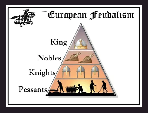
Feudalism describes what it was like living in the Middle Ages: i.e. society was organised by the ownership of land; individuals were given land by people of higher status in return for work and protection. Feudalism emerged in the Anglo-Saxon period when the Romans left, but became more comprehensive and uniform after the Conquest.
A triangle of four tiers is often used to describe feudalism. The king is at the top: he owned the land and made the laws. Vassals (lords, nobles, and bishops) made up the second tier. They were given land by the king, in return for which they supplied the king with knights (mounted horsemen), produce, and prayers. The knights made up the third tier; they defended their lord in return for land (a fief). The fourth, and largest tier, consisted of peasants who owed their labour to the knight and could not lawfully leave. They were expected to help build roads, clear forests - any other tasks the lord wanted doing and were divided into two classes: freemen, and serfs. Serfs paid for the strip of land they tended with a share of their produce. Freemen had more choice in their tasks, and paid for their land in taxes.
 Domesday Book
 The Domesday Book was the great survey of most of England and Wales compiled on the orders of William the Conqueror in 1086. The main purpose of the Book was to record the annual value of each piece of landed property owned by its lord, plus the land, labour force and livestock from which the value was estimated. It was organised by a series of headings. Each heading listed the manors held by vassals-in-chief on behalf of the king; a vassal being either a nobleman or a senior member of the clergy.
Most of Cumberland and Westmorland did not appear in the Domesday Book, as the majority of these areas belonged to the Scottish king in 1086 and prior to that, fell within the Kingdom of Northumbria and before that, the Kingdom of Strathclyde.
However, the southern part of Cumberland, including our area, is included in the Domesday Book. It is called the manor of Hougun, which was owned by the Earl of Northumbria, Tosti (Tostig Godwinson), brother of Harold Godwinson, i.e. King Harold. In 1066, Earl Tosti was killed at the Battle of Stamford Bridge fighting his brother, Harold, who was killed a few months later by William the Conqueror at the Battle of Hastings.
Lancashire Pipe Rolls and Early Charters by W. Farrer published in 1902, says
in Furness and Cartmel there were five large manors, three of which were assessed at six ploughlands each, the fourth with a berewick at seven ploughlands, the fifth, having its chief manor house at Hougun (now Millom Castle in Cumberland) with 26 dependent vills, 22 of which were in Furness and Cartmel, was assessed at 75 ploughlands, making in all 100 ploughlands.
Unlike many other places listed, Hougun manor only includes the owner, the vills within the manor and how many carucates there are in each vill. A carucate is roughly 120 acres. Here is the relevant extract:
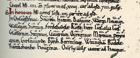
Translated, this says: In Hougun Manor Earl Tosti had four carucates rateable to the geld. In Chiluestreuic iii c., Sourebi iii c., Hietun iiii c., Daltune ii c., Warte ii c., Neutun vi c., Walletun vi c., Suntun ii c., Fordebodele ii c., Rosse vi c., Hert ii c., Lies vi c., Alia Lies ii c., Glassertun ii c., Steintun ii c., Clivertun iiii c., Ouregrave iii c., Meretun iiii c., Pennigetun ii c., Gerleuuorde ii c., Borch vi c., Beretsiege iiii c., Witingham iiii c., Bodele iiii c., Santacherche i c., Hougenai vi c.. All these vills belong to Hougun.
Several of these places still exist but with slightly different names, for example, Sourbi is Sourby, Daltune is Dalton. Witingham is thought to be Whicham; Bodele, Bootle; Santacherche, Kirksanton; but there is a dispute about both Hougun and Hougenai. Some think Hougun is High Haume near Dalton-in-Furness whilst others believe it is Millom. Some say Hougenai is Walney Island whilst others say it is Millom Castle. Clearly saying Hougun Manor has four carucates then at the end saying all of the vills belong to Hougun does not make sense. It makes more sense that Hougun refers to the whole area whilst Hougenai is probably Millom.
Given there is evidence that Bootle, Kirksanton, Millom and Whicham, have been occupied since Prehistoric times and the existence of Bootle, Kirksanton and Whicham in the Domesday Book is not disputed, why is Millom disputed? All four places have ancient churches with Kirksanton church being acknowledged as a daughter church of Millom; and Millom Castle was the administrative centre of Millom Seigniory, it seems logical, therefore, that Hougenai is Millom or Millom Castle.
Origins of Name Millom
It seems likely the name changed from Hougenai to Millum round about (or just before) 1096 when the four manors, Bootle, Kirksanton, Millom and Whicham, were given to Godard de Boyvil who changed his name to Godard de Millum.
Warriner tells us that in 1190 Millom was spelt Millum or Mullum; and in 1228 there are records of it being spelt Myllum. In Old English mylnum means 'the mills.' However, Rev. Bracegirdle suggests the name may derive from the Norse "mel holmr" meaning "the sandy isle in the creek."
During the community dig in 2024 at least two sandpits were discovered in the playground of the Old School, a possible water leat was found in the garden of the school master's house next to the moat which could relate to a water mill and in the 'Urn' field we found traces of grain suggesting there may have been a mill of some sort nearby. Old maps show a mill at Beck's Farm, as well as a sand pit. All food for thought.
Millom Seigniory/Lordship
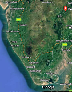
The seigniory or lordship of Millom (sometimes confusingly called Millom Manor), was a country estate consisting of land between the rivers Esk and Duddon (about 18 miles across), down to Haverigg. The seat of the lords of Millom seigniory was at Millom Castle. There were several manors within the Seigniory as well as the parishes of Bootle, Corney, Millom, Waberthwaite, Whicham, and Whitbeck.
During the 12th and 13th centuries parts of the seigniory were given to different families and some given to St Bees Priory and Furness Abbey. A list of lands and rights given to religious establishments is included in the Annals of Millom contained in Rev. William Slater Sykes notebooks held at Whitehaven Archive. Millom and District Local History Society have been given permission from Cumbria Archives, Whitehaven, to put photographs of his notebooks on our website, the Annals are in Chapter One.
Lords of Millom Seigniory
The Rev. Sykes tells us in his Annals that in 1066 William the Conqueror gave the lands once held by Tostig Godwinson, including Millom Seigniory, to Roger de Poitevin but that in 1083 Roger was in rebellion, a consequence of which was that he was deprived of his lands. In 1087 William II gave lands, including those between the Esk and Duddon, to Ivo de Tallebois - Ivo's widow, Lucy's third husband was Ranulf le Mechin.
William le Mechin went on the Crusades (in place of his brother, Ranulf). Godard de Boiville was Ranulf's chief tennant so he too went on the crusade with William. It is assumed that, as a reward for his services rendered in the Crusades to William (and Ranulf), Godard was awarded the lordship of Millom. Thus Godard became the first Lord of Millom and changed his name to Godard de Millum.
The de Milloms held Millom Seigniory for five generations until they ran out of male heirs and Joan de Boyville (de Millom) married John Huddleston in 1240. It remained with the Huddleston family for the next 500 years until 1748 when Elizabeth Huddleston sold it to Sir James Lowther of Whitehaven.
Millom Castle
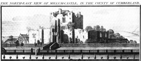
It seems likely that Godard de Boyville built a Manor House on the site of Millom Castle in about 1134, although there may have been a wooden motte and bailey castle which preceded this. It is also possible there may have been some kind of Roman building on the site previously, although evidence for this is still to be found.
In the 14th Century parts of Northern England were subject to Scottish raids. These affected the Millom peninsula in 1316 and 1322 when Whicham parsonage was destroyed; it seems likely it was in response to this that John de Hodleston was given licence by King Edward III to crenellate on 24th August 1335. It reads "Licence for John de Hodleston to enclose with a dyke [moat] and crenellate his dwelling-place of Millum, co. Cumberland."
It is worth noting some 336 years later (1671), Sir Daniel Fleming writes, "King Edward I [1272-1307] gave licence to Sir John Huddleston for to build Millum Castle, which stood until the late Civil Wars demolished it, and now in 1671 Ferdinando Huddleston, Esqre., the present owner, is rebuilding it."
Jura Regalia and Manor Court
Millom Seigniory was run from the Manor House, (Millom Castle). Whilst technically within the Egremont barony, Millom Seigniory was an independent lordship with head courts, usually meeting twice a year in the Court Room of the Castle. Because Millom was a seigniory, the Lords of Millom exercised "Jura Regalia" - power of authority over all their subjects. Even the High Sheriff of Cumberland could not interfere within its boundary.
Manor Courts were held both for the lord and the neighbourhood, the main role was the preservation of the rights of the lord but also regulations of tenant relations. This latter purpose also dealt with breaches of the peace. A third element dealt with criminal affairs and statutory obligations. Manorial records are held at Carlisle Archive. During the 18th Century, copies were made of early court records but unfortunately these only go back to 1497. With the kind permission of the Trustees of the Lowther Estate, these can now be accessed on our website.
Much of what is recorded, such as punishments, would have applied before 1497. Most punishments were fines but some folk were also put in the stocks, the whereabouts of which are unknown. It seems likely, however, they would have been at the crossroads - close by where the Knott branches off the main road near Low House Farm whilst the main road would have continued down towards Aggie's Lonnin.
Millom Gallows
If found guilty, one punishment was hanging. The gallows were placed in Gallows field (previously called Gallows Sewell on old maps) and is near Gallowbank; both are identified on the 1867 Ordnance Survey map. This was once the main road from the Castle to what is now Aggie's Lonning and originally (before the embankment or the train line was built) onto one of the three main crossings from Duddon Sands to the Furness peninsula.
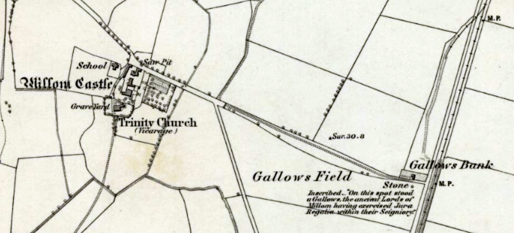
In about 1860 a commemorative stone was erected in the Gallows field, on it was inscribed 'On this spot stood a Gallows the ancient Lords of Millom having exercised Jura Regalia within their Seigniory.' The stone has since been moved to the side of the field and can be seen at the bottom of the lane on the left side (looking upwards towards the castle) but the inscription is no longer visible.
Typical Medieval Manor
A medieval manor usually consisted of the manor house, a church, agricultural land, a village to house the farm workers, and sometimes woods, orchards, gardens and ponds for fish. We know from old maps that Millom Manor House/Castle had all of these features as well as a dove cote.
Religion - Holy Trinity Church
There was likely a religious building which preceded Holy Trinity Church (evidenced by the 10th Century Anglo-Saxon cross built into external wall of church).

Mary Fair (1874-1955), prominent member of CWAAS, suggested it was Godard de Boyville who was the founder of Holy Trinity Church, which would date it to about the middle of the 12th century. In fact, a King John (1199-1216) silver penny was found by a local metal detectorist not too far from the Castle which could support this.
The Roman Catholic church played a major role in Medieval England. It influenced virtually every aspect of the lives of individuals, with the teachings of the church and its rituals, and a strong belief in god. Religion permeated all levels of society. People believed that they would be judged by god according to their sins and would go to either heaven or hell. Monasteries and priories were powerful, owning lots of land, much of which came from the gifts of barons, with the promise of prayers for the salvation of the souls of those departed.
Ampullae
Medieval ampullae are small flasks usually made of lead which were used to hold holy water or oil. They were often bought by pilgrims at shrines, and could be tied round the neck with string, or the contents used to bless fields for a good harvest. Two ampullae have been found by metal detectorists in fields not far from Millom Castle.

According to the Rev. Sykes, there were salt works in Kirksanton, Arnaby and Millom which were constructed by monks. He assumes Salt House farm preserves the site of the boiling house for the one in Millom and suggests the Lords of Millom may have worked the saltern before the monks were given it some time before c.1240. For further information see Sykes' Snippets
Deer Parks
In keeping with other country estates of this period, there were two deer parks, one that began at the Hill and almost went down to Kirksanton, with maps suggesting it may have surrounded much of the Castle, as well as a very large one at Ulpha. These probably came into existence in the 13th Century. We held an event to look at hunting in September 2023. Here is a link to a presentation given at the event: Medieval Hunting.
Deserted Village
A small village would have developed near the Castle. Historic Environment Records suggests a deserted village in the field behind the churchyard (in front of the Castle) but Rev. Sykes places the deserted village where the farm buildings of the Castle are.
Market Charter and Annual Fair
A charter for an annual fair over the feast of Holy Trinity and a weekly Wednesday market was granted by King Henry 3rd in 1251 to Sir John Hudleston:
We have granted and by this charter have confirmed to John de Hudelston that he and his heirs in perpetuity shall have a weekly market on Wednesday at his Manor of Millom in the County of Cumberland.
And that they shall have an annual fair lasting three days, namely from the vigil to the morrow of the feast of Holy Trinity, unless that market and fair proves to be harmful to neighbouring markets and fairs.
Therefore we wish and firmly command for us and our heirs that the aforesaid John and his heirs shall hold in perpetuity the said market and fair at his manor aforesaid with all liberties and free customs appertaining to such a market and fair unless that market and fair proves to be harmful to neighbouring markets and fairs aforesaid.
These being witnesses, the Venerable Father Aymer bishop elect of Winchester, William de Valence, Geoffrey de Lusignan, our brothers Master William of Kilkenny Archdeacon of Coventry, Peter de Rievaulx, Bertram de Croil, Robert Walerand, William Germon, Roger Lokinton and Others.
Given under our hand at Merewell 22nd day of July in our reign (1251).
We know virtually nothing about the market and fair but are told that the market had long been discontinued in 1777. In fact, there appears to be no records appertaining to the market in the records of Bridget Huddleston, 1701-1703, suggesting it was no longer active by then.
It seems likely the market would have been held near the church and castle - the amount of coins found in this vicinity by local metal detectorists would appear to support this.
John de Huddleston was also granted a charter for a weekly market and annual fair at Bootle in 1347. Bootle market faired better than the one at Millom, lasting until the mid-19th Century, with a cattle market and hiring fair for servants continuing after that.
Many of the markets and fairs introduced in the Middle Ages did not survive; a lot ceased to exist during the 14th Century due to a decline in the climate resulting in poorer crops, some sort of foot and mouth disease, and the Black Death which reduced the population by about 50%.
Community Dig
Many Medieval objects were found in the three trenches (Old School playing field and School Master's Garden) during the Community Archaeology dig of summer 2024. These included the largest ever find of Medieval pottery in this part of the county; an Edward I silver penny; and a tiny strap fitting in the shape of a stirrup, dated 13th to 14th century:
 More information can be found
here.
More information can be found
here.